Dashoguz Province
| V・T・E Dashoguz Province, Turkmenistan, Central Asia Daşoguz welaýaty |
| latitude: 41.079, longitude: 58.656 |
| Browse map of Dashoguz Province 41°04′44.40″ N, 58°39′21.60″ E |
| Edit map |
|
External links:
|
| Use this template for your city |
Dashoguz Province is a province in Turkmenistan, Central Asia at latitude 41°04′44.40″ North, longitude 58°39′21.60″ East.
Notes on Dashoguz Province
Dashoguz Province (Daşoguz welaýaty) features one major city, its capital city, which bears the same name as the province. It was known as Tashauz (Russian: Ташаузская область, Tashauzskaya oblast', Turkmen: Taşauz oblasty) during the Soviet period. To this day one may hear Russian speakers refer to Dashoguz Province by the Soviet Russian name. For other variants of the name used at different times, please see Turkmenistan Geoname Changes.
Administrative Subdivisions
See also Districts in Turkmenistan and Turkmenistan Geoname Changes
Map of Districts (Etraplar) of Dashoguz Province
As of 9 November 2022, Dashoguz Province (Daşoguz welaýaty) is subdivided into 8 districts (etrap, plural etraplar):[1][2][3]
- Akdepe
- Boldumsaz
- Görogly (previously Tahta)
- Gurbansoltan Eje
- Köneurgenç
- Ruhubelent
- Şabat (formerly S.A. Nyýazow adyndaky)
- Saparmyrat Türkmenbaşy adyndaky
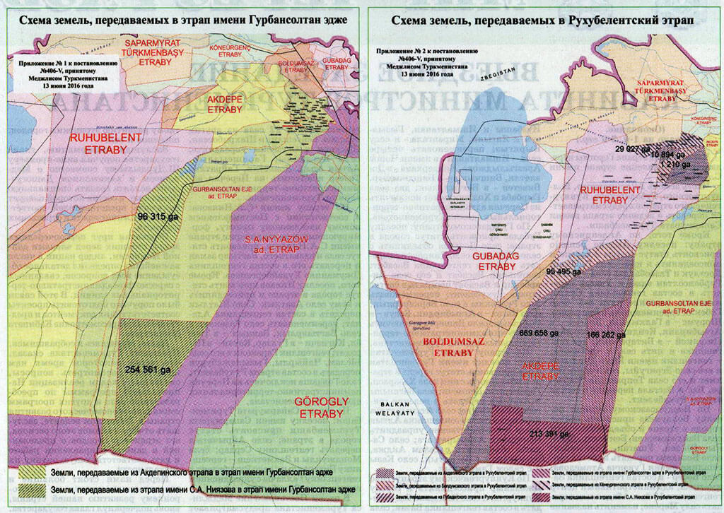
The parliamentary decree of 9 November 2022 abolished Gubadag etraby and transferred all its territory and municipalities to Boldumsaz etraby.
As of 9 November 2022, the province includes 9 cities (города or şäherler), 7 towns (посёлок or şäherçe), 126 rural or village councils (сельские советы or geňeşlikler), and 594 villages (села, сельские населенные пункты or obalar). One city enjoys legal status equivalent to a district:[4][1][2][3]
- Dashoguz
See Also
Reference Materials
- Дашогузский велаят (Dashoguz Province on the Academy of Sciences website)
- Изменения в административно-территориальном делении Дашогузского велаята (Changes in the Administrative-Territorial Division of Dashoguz Province) 17 June 2016
- ПОСТАНОВЛЕНИЕ МЕДЖЛИСА ТУРКМЕНИСТАНА Об административно-территориальных вопросах Дашогузского велаята (Decree of the Turkmenistan Parliament On Administrative-Territorial Issues of Dashoguz velayat) 17 June 2016
- Рассмотрены вопросы совершенствования административно-территориального устройства велаятов 22 October 2022
- Постановление Меджлиса Милли Генгеша Туркменистана 10 November 2022
- Türkmenistanyň Milli Geňeşiniň Mejlisiniň Karary 10 November2022
References
- 1 2 “Рассмотрены вопросы совершенствования административно-территориального устройства велаятов” (in ru). Государственное информационное агентство Туркменистана (TDH) - Туркменистан сегодня. 22 October 2022.
- 1 2 “Постановление Меджлиса Милли Генгеша Туркменистана” (in ru). Государственное информационное агентство Туркменистана (TDH) - Туркменистан сегодня. 10 November 2022.
- 1 2 “Türkmenistanyň Milli Geňeşiniň Mejlisiniň Karary” (in tk). «Turkmenistan: Golden age». 10 November2022.
- ↑ “Административно-территориальное деление Туркменистана по регионам по состоянию на 1 января 2017 года”.